Dflip
-
Posts
2935 -
Joined
-
Last visited
Content Type
Forums
Events
Gallery
Everything posted by Dflip
-
Speaker placement is very important, an inch can make a difference between the sound stage and the bass. It's a compromise, but that small increment between spacing away or closer to the back or side wall will affect the sound. Take a listen and move it 3" at a time, when it doesn't sound better, reverse direction by an inch. The final placing is less than an inch and takes a few listens, but is well worth it.
-
The fourth was the Super Bowl with New Orleans winning, the third with the opening ceremonies for the Olympics in Vancouver, the second last Sunday with the Canada-US hockey game (which also had the largest audience of any program in the US on CNBC that night) and tonight's Olympic quarter final game with Canada against the Russians. I was at a supermarket an hour before the game and it was empty. Canadians love hockey more than Americans love football. 4-1 at the moment, but we need to up the play by a level at bit at the moment. For those of you who don't know, Canada vs. Russia has been a very big deal since Paul Henderson scored to win the Summit Series in 1972. Games against the U.S. are more recent, and while big games, they don't stir the same emotion in us as a game against Russia. The NHL is like the minor leagues compared to the level of hockey being played tonight. The U.S. has a very good team, but the stars of the NHL are playing tonight. The only person missing is the best goalie this year, Ryan Miller of the Buffalo Sabres who is the U.S. goalie. Sorry that most of you can't see it. It is great hockey and what the game can really big, not Gary Betman's N.B.A. light.
-
Must be global warming because we had a green Christmas in Toronto. Yesterday we had an 1/8th of an inch and I've shoveled once this winter so far. Very light for the great white north. compared to the deep south. lol Enjoy the snow, I'm sure nobody knew how to drive in it. Those old bawled tires don't work too well in the white stuff, unless you like a lot of slipping and sliding.
-
Unless it takes a turn towards the west - southwest, it's going to run out of steam and hit colder water.
-
Glad to hear it worked out for your parents. If it wasn't for the scathing emails, phone calls and negative comments towards the dealership and BMW, then those in charge of this deal would have gladly ripped off your parents. It's a shame that it took getting caught with the hands in the cookie jar before they fixed the problem.
-
It's upgraded a level. It's still a long way out and has the potential to increase strength, but it can also burn itself out as it passes the leeward islands. Still worth keeping a good eye on to see what it's like when it crosses these islands.

-
Erika is now headed towards Florida, but it's listed as a pretty small storm after 5 days. It could pick up after that, but it seems to be getting less intense each day. The next storm on the list is no longer posted, but off the coast of Africa there is the making of a good storm, but a lot can happen between now and when it approaches the leeward islands. It's been quiet so far, hopefully it will continue. We are already at the first of September without a major hurricane.
-
Erika is moving very slowly at the moment and making the same turn towards the north Atlantic that Bill and Danny made. So far so good, but there is another storm behind Erika.
-
The latest update before I go on a three day vacation. The storm in the Atlantic has intensified. It should be interesting to see what it looks like when I get back. Probably a good chance that it will at least have a name and may be significantly stronger. Labour Day is approaching and this storm looks like it fits that general time frame. According to the projected paths that Marshal just posted, most hurricanes this year are being subjected to the push to the north this year once they hit the leeward islands. As a result they are getting caught up in the Gulf Stream and carried into the North Atlantic, which has been a good thing so far.
-
Groomie, nice to see you back. I'm go on a short holiday just before school starts back up on Wednesday, so I won't be posting for a few days. I will leave it up to you to post on any changes in the hurricane outlook. It's been a very mild year so far, sort of the like the summer here in Toronto. I think we've had six days that in the past we would truely have called summer. Danny seems to be winding down and is really just a rainmaker of the eastern seaboard. It's now raining outside the church in Boston at the end of the Ted Kennedy funeral and will probably cancel out the Red Sox vs. Jays game. The other system in the Atlantic is a bt less threatening today, but it still has a long way to go with warm water between it and the Caribbean. It could still reintensify.
-
The potential Erika has moved up a category to orange and shows signs of intensifying. "A TROPICAL WAVE IS LOCATED OVER THE FAR EASTERN ATLANTIC OCEAN ABOUT 350 MILES SOUTH-SOUTHWEST OF THE CAPE VERDE ISLANDS. THE ASSOCIATED SHOWER ACTIVITY CONTINUES TO SHOW SIGNS OF ORGANIZATION...AND SLOW DEVELOPMENT OF THIS SYSTEM IS POSSIBLE OVER THE NEXT COUPLE OF DAYS AS IT MOVES WESTWARD AT 10 TO 15 MPH. THERE IS A MEDIUM CHANCE... 30 TO 50 PERCENT...OF THIS SYSTEM BECOMING A TROPICAL CYCLONE DURING THE NEXT 48 HOURS." Danny has been downgraded to a tropical storm at the moment, including when it hits Nova Scotia. It continues to track more eastwardly in Nova Scotia and hopefully continues this path where it's edge will hit the province, instead of what's left of the eye.
-
http://www.stormpulse.com/ has an interesting visual view of Danny and it's path. It's projected path has moved slightly further out to sea along the U.S. coast, about 150 miles off shore and will now hit the south side of the Bay of Fundy. If the path continues to go a bit more out to sea, then Nova Scotia may receive less impact. I don't image the people want to lose their power twice in one week. The other system is a bit better organized and taking a lower path which puts the Caribbean and maybe even the Gulf into the mix. It's worth tracking to see if it intensifies after the weekend and where it's headed.
-
spike feet for 1980 cornwalls on carpeted floors?
Dflip replied to heresy&jolida's topic in Technical/Restorations
I have spikes on the bottom of my Cornwalls. I think it may have helped a bit, at least it got them off the floor. They are heavy, but two arms around the back and a gentle solid lift will move them. It would be easier with two people, but can be done by one. I might suggest putting some tape down on the floor if you are fine tuning them (moving them an inch or less at a time). A bit more difficult to move, but they stay in one place and sound good. Don't forget the fine tuning, a small movement away from or towards the wall does make a difference. My friend who isn't an audiophile, was able to her the difference with her own ears when I had to move the speakers slightly after getting a new cd player. -
Danny will intensify a bit, but is still scheduled to miss the east coast of the U.S. It looks like it will reach hurricane status when it's off the coast of New Jersey. I'm sure the areas will receive higher winds and tides, but not a direct hit. The next storm is already forming off the coast of Africa. It's approaching Labour Day weekend which seems to be a favourite time for a more intense hurricane. I suspect we will see a couple more storms forming up over the next two to three weeks. Hopefully they stay disorganized and head out towards the North Atlantic, just like Bill.
-
http://www.stormpulse.com/tropical-storm-claudette-2009
-
Hurricane Dan looks like it will be off the coast of the North Carolina barrier islands and close to Long Island and hit Nova Scotia again. Usually Nova Scotia counts hurricanes by the years, almost a decade between them. Now they are going to have two within a week.
-
I had my first tomato sandwich today. Freshly ground kosher salt, mixed pepper and 5 year old cheddar cheese. I do like this time of year. The plants have three to four tomatoes on most plants which isn't great, but one of the heirlooms has twelve tomatoes. It hasn't been a great year, too cold and wet, but I still have some tomatoes and I will be eating sandwiches for the next couple of weeks.
-
Bill is now a category 3 hurricane (120 mph), but the winds look like they will hit both Nova Scotia and Newfoundland stronger than originally forecast. As for the U.S., some waves on the coast, particularly Long Island, but no direct hits.
-
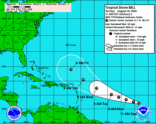
Yes, Bill is a Cat 4 hurricane at the moment. The most important thing to look at is it's path. It avoids the leeward islands and misses Bermuda. The only places that need to be worried are Nova Scotia and Newfoundland, both in Canada. It will still be a significant storm when it hits this area. As with all hurricanes, it's what where they track and do they hit a major populated area or not. Included is the most recent tracking forecast for Bill.
-
Todays forecast has Ana becoming less powerful, less than 39 mph winds. Bill continues to head to the north towards Bermuda and at that point it will be just under hurricane strength. Good news so far, but just remember, we are now in hurricane month, mid August to mid September. The west coast of Africa is now showing a lot of disorganization, but a new cell starts every couple of days.
-
The latest on Bill. It seems to be heading into the north Atlantic with Bermuda being a possible target. So far so good for the U.S. Just remember, it's still early and it's course could change. Another interesting site, http://www.nhc.noaa.gov/satellite.shtml. Go to the METEOSAT-8 satellite and choose water vapour loop, you will be able to see potential hurricanes forming up over western Africa. You may have to slow down the loop speed to properly view it.
-
The latest on Ana. It's showing as a tropical depression when it hits the Gulf of Mexico. Hopefully this continues. It's current path is right through Cuba which will steal a lot of it's strength.
-
Anna appears to be a tropical storm which is going south of the Key West area. It might strengthen a bit when it reaches the Gulf. It is moving pretty quickly at the moment, so it's impact will be over faster than some. Bill is scheduled to be a cat 2 hurricane before it reaches Puerto Rico. Of course, it depends where it goes from there, northwards towards the Carolinas or more southerly and ultimately towards the Gulf. It's definitely worth tracking as we approach next weekend. It has lots of time to make up it's mind and change course.
-
Triplicate post.
-
Duplicate post.